
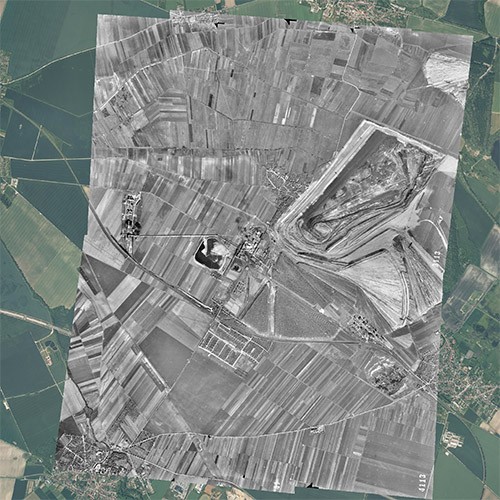
Remote sensing is used to obtain information about the earth's surface with the help of electromagnetic waves (e.g. light) or by means of sound waves. In contrast to other methods, remote sensing enables the non-contact investigation of large areas of the Earth's surface. It is used for mapping in surveying and cartography, for data acquisition in geoinformation or for monitoring natural and anthropogenic changes in areas of interest. Remote sensing offers the possibility of recording large areas in high temporal and spatial resolution and is of great importance for a wide range of specialist areas such as (e.g. regional planning and land use planning, agriculture and forestry, civil engineering, architecture, archaeology, industry, etc.).
- The thematic evaluation of historical and current aerial photographs with regard to different issues (explosive ordnance, contaminated sites, land use, environment, etc.).
- the orthorectification and georeferencing of historical and contemporary imagery
- the creation of orthophotos and orthophoto mosaics
- Deriving digital terrain and surface models (DTM, DOM) from current aerial photographs and drone flights
- the reconstruction of historical terrain surfaces
- The collection and processing of aerial photographs and subsequent products by means of UAV (Unmanned Aerial Vehicle)/drone flights for the purpose of monitoring, volume calculation and determination of surface and volume changes, e.g. in the context of construction site documentation, soil management, waste management, open-cast mining, environment, etc.
Your contact
Departmental Coordinator
CONSTRUCTION MANAGEMENT
Norbert Tümmers  norbert.tuemmers@mup-group.com
Geographic information systems (GIS) are an essential tool in all matters of spatial and environmental planning. They can be used to digitally capture, process, organise, analyse and present geoinformation.
In recent years, both a constantly growing need and an equally growing availability of geodata and geoinformation as a basis for planning and decision-making processes can be observed, so that the use of geoinformation systems is becoming more and more important in all areas. Mull und Partner Ingenieurgesellschaft has a high-performance team of geo-academics and GIS specialists who guarantee the prompt and customer-friendly solution of your tasks and questions in the following areas:
norbert.tuemmers@mup-group.com
In recent years, both a constantly growing need and an equally growing availability of geodata and geoinformation as a basis for planning and decision-making processes can be observed, so that the use of geoinformation systems is becoming more and more important in all areas. Mull und Partner Ingenieurgesellschaft has a high-performance team of geo-academics and GIS specialists who guarantee the prompt and customer-friendly solution of your tasks and questions in the following areas:
- Geodata acquisition, processing, analysis and presentation
- Data migration and conversion
- Structuring and optimisation of geodata inventories
- Development of specialised databases and individual GIS solutions, e.g.
- Conception and development of the Information System for Soil and Groundwater Protection (INSA) as a central federal database for the uniform documentation of contaminated site management.
- Berlin Senate Department: database development and operation for the management of all potentially explosive ordnance-relevant objects and structures in the Senate Department's area of responsibility.
- Conception and provision of complete "GIS" solutions according to the individual wishes and requirements of our customers
- Database-based 3D soil models
- Web portal development as an information and management system for numerous specialist applications
Your contact
Departmental Coordinator
CONSTRUCTION MANAGEMENT Norbert Tümmers norbert.tuemmers@mup-group.com